


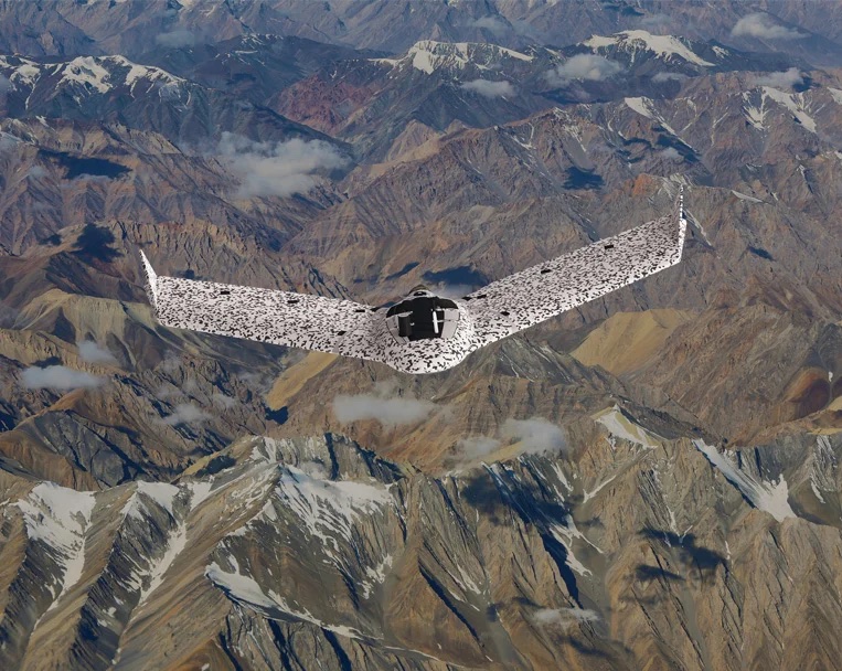
In an ever-evolving landscape of technology, innovation takes center stage, and eBee TAC stands as a remarkable embodiment of this progress. If you’re searching for a transformative mobile mapping solution that seamlessly navigates disconnected environments, your search ends here. Let’s dive into the platform of eBee TAC and see how it’s revolutionizing the art of precise analysis and swift action in dynamic landscapes.
Exploring Boundless Horizons
eBee TAC proudly introduces a mobile mapping solution that thrives even in the absence of constant connectivity. In a world where traditional mapping methodologies face limitations, this innovation rises above by offering exceptional accuracy and effortless data sharing. In environments that are constantly shifting, the value of precision and prompt data dissemination cannot be overstated. This US-owned company, in partnership with its Swiss subsidiary, has ingeniously designed a portable masterpiece that’s not only transportable but also operable and maintainable without the need for external support.
Unrivaled Features of eBee TAC
eBee TAC is more than just a drone; it’s a technological marvel equipped with features poised to redefine mapping:
- Lightness and Agility: Weighing just 3.5 lbs, eBee TAC is synonymous with agility. Its portability ensures readiness in any situation, wherever the need arises.
- Swift Deployment: Time efficiency is paramount, and eBee TAC embodies this principle. It can be deployed within a mere 3 minutes, ready to soar and capture data promptly.
- Extended Flight Time: With up to 90 minutes of flight time, eBee TAC can cover expansive ground, ensuring that no critical detail goes unnoticed.
- Vast Mission Coverage: Encompassing anywhere from 544 to an astounding 1,235 acres at 400 ft altitude, eBee TAC ensures precision over extensive territories.
- Silent Radio Mission: Operating noiselessly, eBee TAC blends into the environment while efficiently executing its missions.
- Exceptional Accuracy: Mapping accuracy is paramount, and eBee TAC delivers with an astonishing 0.6-inch mapping accuracy.
- Seamless Data Workflow: eBee TAC smoothly handles the entire data workflow, from capture to processing.
- Optimal Field Performance: eBee TAC’s design optimizes data collection for real-world applications, performing exceptionally in the field.

Empowered by eMotion Flight Planning Software
Complementing its prowess is the eMotion Flight Planning Software, a tool that propels the drone into the skies efficiently, equipped with geospatial data collection and management functionalities. Offering offline flight planning, MGRS coordinates utilization, 3D flight planning, and automated mission blocks, eMotion takes efficiency to new heights.
Elevated Security Measures
Security is paramount for eBee TAC:
- Data Encryption: eBee TAC ensures data privacy with Radio Data Link Encryption utilizing AES-256.
- Stealth Mode: Maintaining a minimal visible signature and acoustic undetectability, eBee TAC operates discreetly.
- Stringent Approval: Blue UAS approval emphasizes eBee TAC’s commitment to adhering to rigorous standards.
Immediate Data Transformation
eBee TAC’s payload modularity enables immediate data transformation. Gathered data is instantly accessible via the SD card, facilitating swift analysis and informed decision-making.
eBee TAC marks a monumental leap in mobile mapping technology. Its capability to function in disconnected environments, coupled with its unmatched accuracy and security features, positions it as a transformative force. This US-owned venture, aided by its Swiss subsidiary, has birthed not just a drone, but an innovation that’s steering mapping into a new era. Be it research, analysis, or decision-making, eBee TAC stands as the quintessential companion in navigating the intricate realm of geospatial data.
Navigating the Heights of Excellence: Unveiling eBee TAC’s Technical Marvel
In the realm of technological innovation, details are the building blocks of greatness. Let’s dissect the technical specifications that underpin the eBee TAC, a mobile mapping wonder, and unravel how each element contributes to its extraordinary performance.
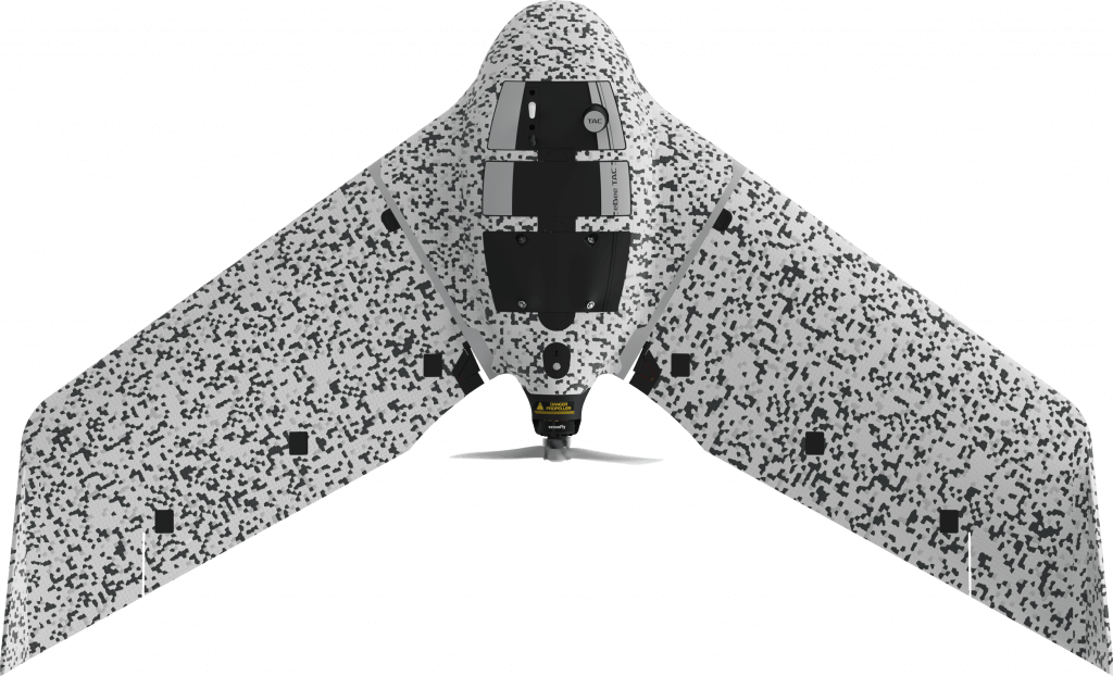
Design and Craftsmanship of eBee TAC
– Impressive Wingspan: With a wingspan of 116 cm (45.7 inches), eBee TAC conquers vast territories during its missions.
– Material Mastery: Crafted with precision, the drone’s body features Expanded Polypropylene (EPP), ensuring durability and resilience.
– Innovative Underbody Skin: The underbody skin, composed of Curv® Polypropylene thermoplastic composite, further enhances the drone’s sturdiness and aerodynamic efficiency.
– Exceptional Take-off Weight: Despite its compact size, eBee TAC boasts a maximum take-off weight of 1.6 kg, showcasing its impressive payload capacity.
Practicality and Portability
– Optimal Transport: The drone’s transport case dimensions, measuring 75 × 51 × 33 cm (29.5 x 20.1 x 13.0 inches), ensure convenient transportation during missions.
eBee TAC Flight Performance and Capabilities
– Propulsion Excellence: Driven by a low-noise, brushless, electric motor, eBee TAC guarantees efficient and noise-free flights.
– Detachable Wing: The detachable wing design simplifies transport and maintenance, amplifying the drone’s versatility.
– Strong Communication: A nominal range of 3 km (extensible to 8 km) ensures seamless communication between eBee TAC and the operator during flights.
– Stable Connectivity: Operating within the 2.400 – 2.4835 GHz frequency range, the drone maintains stable and uninterrupted communication.
– Impressive Cruise Speed: Capable of cruising at 40 to 110 km/h (11-30 m/s or 25-68 mph), eBee TAC ensures rapid and efficient data collection.
– Unyielding Wind Resistance: Confronting winds up to 46 km/h (12.8 m/s or 28.6 mph) with poise, the drone remains stable in challenging weather conditions.
– Precision Landing: Embracing linear landing with Steep Landing technology, eBee TAC achieves 5 m (16.4 ft) accuracy within a 35° angle cone.
Adaptability to Environments
– Operational Temperature Range: Operating effectively between -15°C to 40°C, eBee TAC effortlessly adapts to a wide range of environmental conditions.
– Humidity Resilience: Able to operate even in light rain, eBee TAC proves its mettle in adverse weather conditions.
Advanced Capabilities
– Obstacle Avoidance: Featuring LiDAR technology, the drone evades ground obstacles with a range of up to 120 meters.
– Precision Data Resolution: Exhibiting ground resolution as fine as 1.5 cm, eBee TAC captures intricate details with unparalleled precision.
Missions Redefined
– Extended Flight Time: A remarkable 90-minute flight time empowers eBee TAC to cover expansive areas without frequent recharging.
– Comprehensive Mission Coverage: Enabling mission coverage ranging from 220 hectares to 500 hectares at 120 meters (400 feet) altitude, the drone excels in expansive data collection.
– Extended Linear Reach: eBee TAC extends its reach with linear coverage of up to 27.7 km (17.2 miles) during its out-and-back flights.
eBee TAC at Tough Stump Technologies
Every aspect, from its resilient build to its unmatched flight capabilities and advanced features, amalgamates to deliver accurate and efficient data collection across diverse environments. Beyond being a mere drone, eBee TAC signifies high-performance ingenuity that’s redefining the horizons of mobile mapping.
Interested in purchasing the eBee TAC? Reach out to our team.


Comments +